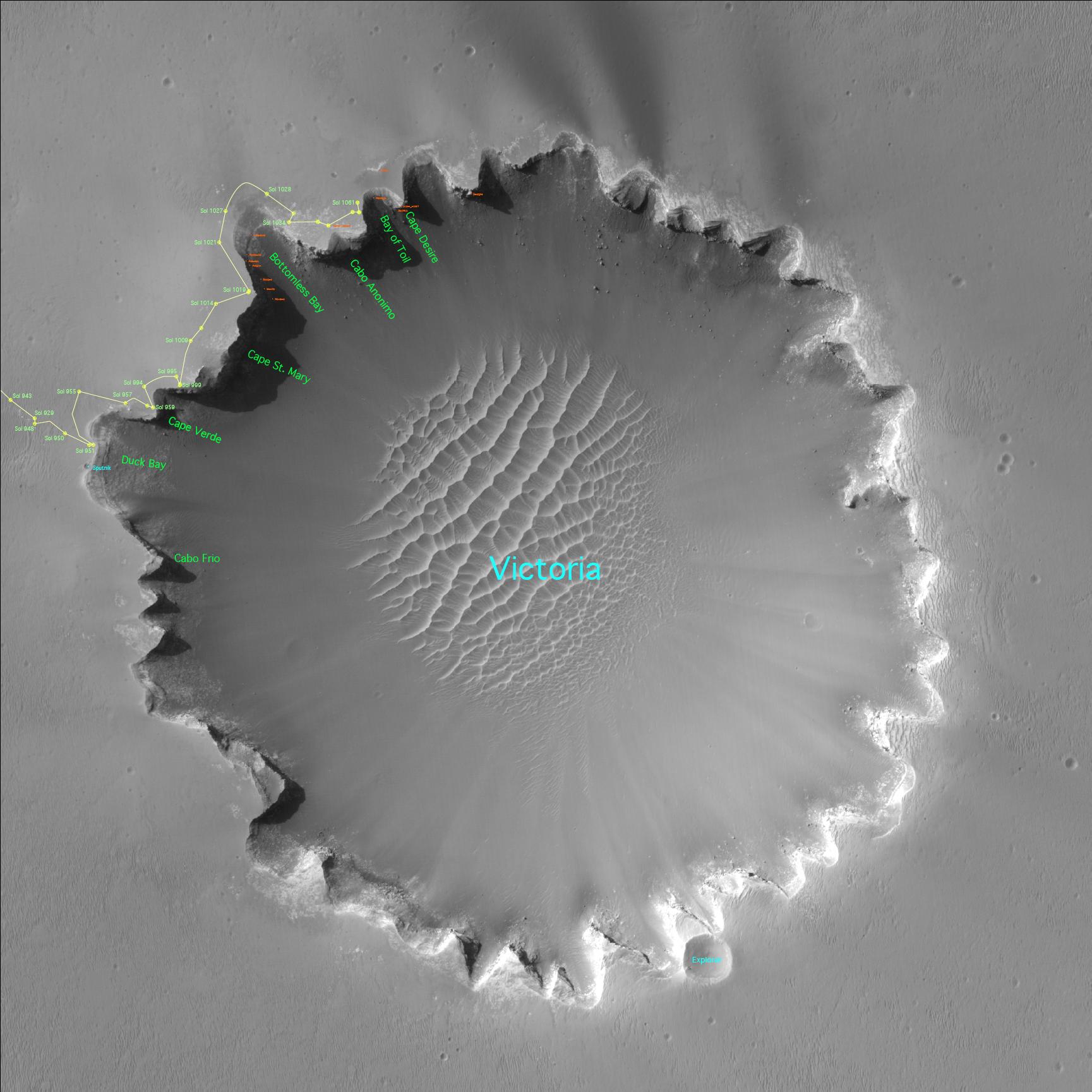
Three years after embarking on a historic exploration of the red planet and six miles away from its landing site, NASA’s Mars Exploration Rover Opportunity is traversing „Victoria Crater“ ridge by ridge, peering at layered cliffs in the interior. To identify various alcoves and cliffs along the way, science team members are using names of places visited by the 16th-century Earth explorer Ferdinand Magellan and his crew aboard the ship Victoria, who proved the Earth is round.
Satellite View of Opportunity’s Journey around „Victoria Crater“ (Annotated)
Kategorie: Mars
Mars may still have large amounts of water
Much of the water and carbon dioxide that Mars had early in its history may still be locked up within the planet. In a paper published in the journal „Science“, researchers said that the rate of escape of water and carbon dioxide from the Martian atmosphere, as measured by an instrument on ESA’s Mars Express spacecraft, is only a small fraction of what was earlier believed. Scientists had previously thought that most of the carbon dioxide and water the planet had early in its history had been stripped from the atmosphere by solar winds. However, at the current rates of escape, only a small fraction of that original supply would have been lost. Researches argue that either much of the carbon dioxide and water is locked up in hidden subsurface deposits, or that other mechanisms stripped the planet of those volatiles.
HiRISE Camera Shows Mojave Crater Peak
The HiRISE camera on NASA’s Mars Reconnaissance Orbiter took a huge, detailed image of Mars‘ Mojave Crater on January 7, 2007. The image shows the central uplift structure in the crater. Rocks that form this peak were several kilometers beneath the surface until an impact formed the 60 kilometer-diameter crater just north of Mars‘ equator. The HiRISE image also shows that boulders as large as 15 meters across have eroded from the massive uplifted rock and rolled downslope.
http://hiroc.lpl.arizona.edu/images/PSP/diafotizo.php?ID=PSP_002101_1875
A Stellar Moment Frozen In Martian Time
An image of sunset on Mars, taken by Spirit, won in a public poll. This contest, and other new multimedia pieces, help mark the twin rovers‘ third anniversary on the red planet. On May 19th, 2005, NASA’s Mars Exploration Rover Spirit captured a stunning view as the Sun sank below the rim of Gusev crater on Mars. The Panoramic Camera (PanCam) mosaic was taken around 6:07 in the evening of the rover’s 489th martian day, or sol.
https://mars.nasa.gov/mer/gallery/press/spirit/20050610a.html
New NASA Orbiter Sees Details of 1997 Pathfinder Site
The high-resolution camera on NASA’s Mars Reconnaissance Orbiter has imaged the 1997 landing site of NASA’s Mars Pathfinder, revealing new details of hardware on the surface and the geology of the region.
https://www.jpl.nasa.gov/news/new-nasa-orbiter-sees-details-of-1997-pathfinder-site
Opportunity rocks, Spirit rolls
In 2004, two mobile robots landed on Mars and began exploring, a gig expected to last only for three months. That has now stretched into three years and the rovers are on the verge of more important discoveries. Despite mechanical problems and challenges that came close to grounding Opportunity and Spirit, both are still going strong as they start their fourth year. Luck seems to always be with the rovers. Power supplies drop dramatically when dust piles up on the rovers‘ solar panels, but the Martian winds always clean them up. When a wire failed in a motor on Opportunity’s arm, the rover had to pause in its trek towards the large Victoria Crater. The spot where it stopped gave scientists their best example of a pattern in rocks that shows liquid water once flowed on the surface of Mars.
Meanwhile, engineers have written and uploaded new software to teach the rovers smarter ways of operating. For instance, a rover will automatically start exploring a target after reaching it. NASA approved a fourth mission extension for the rovers that will last for a year. The cost so far is $894 million, and $27 million more will continue the mission into 2008…
NASA Mars Team Teaches Old Rovers New Tricks to Kick Off Year Four
Spacecraft Reads Layered Clues to Changes on Mars
Some of the first radar and imaging results from NASA’s newest Mars spacecraft, the Mars Reconnaissance Orbiter, show details in layers of ice-rich deposits near the poles. Observed variations in the layers‘ thickness and composition will yield information about recent climate cycles on the red planet.
https://mars.nasa.gov/mro/newsroom/pressreleases/20061213a.html
Buried Craters Found on Mars
Scientists are finding an older, craggier face of Mars buried beneath the surface, thanks to pioneering sounding radar aboard the European Space Agency’s Mars Express spacecraft. Radar echoes captured by the MARSIS (Mars Advanced Radar for Subsurface and Ionospheric Sounding) instrument strongly suggest there are ancient impact basins buried beneath the lowland smooth plains of the Martian northern hemisphere.
Geologists Finding a Different Mars Underneath
Bridge in Tartarus Colles
A stunning new image from the Mars Reconnaissance Orbiter shows a natural „bridge“ over a trough in the Tartarus Colles region of Mars, where a lava tube has collapsed, except for a small portion, creating an arch over the trough. The „bridge“ is about 23 metres wide.
Narrow Trough in Tartarus Colles
New Spurts of Water Discovered on Mars
Just when you thought Mars was dead, it goes and surprises you. Images released from the Mars Global Surveyor show new gullies on the surface of Mars that formed within the last 7 years. The shape and path taken down the slope suggests that they were carved by rushing liquid water. It’s possible that there are quantities of liquid water underneath the surface, which can escape to the surface from time to time. Even though Mars can get cold, researchers think that water spurting out of the ground could last long enough to carry debris down the slope of a hill before freezing solid.
NASA Images Suggest Water Still Flows in Brief Spurts on Mars