A new 3D picture of the geology of Western Australia, captured by measuring seismic waves from deep in the Earth’s crust, has provided evidence that it was created when vast regions of ancient world slammed into each other.
Ancient rock collisions may have formed W.A.
Kategorie: Geologie
Earth's Core-Mantle Boundary: Now In High Resolution Images
High-resolution images that reveal unexpected details of the Earth’s internal structure are among the results reported by MIT and Purdue scientists in the March 30 issue of „Science“. The researchers adapted technology developed for near-surface exploration of reservoirs of oil and gas to image the core-mantle boundary some 2.900 kilometers beneath Central and North America.
https://news.mit.edu/2007/mantle
Geophysicists Find Evidence Of First Plate Tectonics
Identification of the oldest preserved pieces of Earth’s crust in southern Greenland has provided evidence of active plate tectonics as early as 3.8 billion years ago, according to a report by an international team of geoscientists in the March 23 edition of „Science“. The finding pushes back the date of continent-forming processes previously determined as 2.5 billion years ago to a much earlier era considerably closer to Earth’s formation some 4.5 billion years ago. Geochemical analysis of rocks has previously suggested an earlier date for plate tectonics, but this is the first study to find physical evidence of tectonics among Earth’s oldest known rock structures.
Article @ Scripps Institution of Oceanography
Robot to study hole in Earth’s crust
British scientists have embarked on a mission to study a gigantic hole in the Atlantic seabed – an enigma that defies traditional geophysical theory and will give researchers an unprecedented look into the center of the Earth. The 12-person team left the Canary Islands on Monday with a new high-tech vessel and a robotic device named TOBI (Towed Ocean Bottom Instrument) that will dig up rock samples at the bottom of the crater and film what it sees. The hole is about 16.400 feet under the surface of the Atlantic and located half way between Tenerife and Barbados. It has a diameter of 10.000 to 13.000 feet. The mysterious orifice is in an undersea mountain range, the kind of structure believed to form when Atlantic tectonic plates separate and volcanic lava surges upward to fill the gap in the earth’s crust. But that did not happen this time. Instead, the hole exposes the mantle.
Scientists uncover the mystery of the Atlantic’s missing crust
First evidence for water existing in Earth's deep mantle
A seismologist at Washington University in St. Louis has made the first 3-D model of seismic wave damping – diminishing – deep in the Earth’s mantle and has revealed the existence of an underground water reservoir at least the volume of the Arctic Ocean. It is the first evidence for water existing in the Earth’s deep mantle.
Evidence from Hawaiian Volcanoes Shows That Earth Recycles its Crust
A geologist at Rutgers, The State University of New Jersey, has come up with evidence our planet practices recycling on a grand scale. Writing in the prestigious British science journal „Nature“, geological sciences professor Claude Herzberg offers new evidence that parts of the Earth’s crust that long ago dove hundreds or thousands of kilometers into the Earth’s interior have resurfaced in the hot lava flow of Hawaiian volcanoes.
https://www.rutgers.edu/news/evidence-hawaiian-volcanoes-shows-earth-recycles-its-crust
Erdrutsch am Ätna sandte Flutwelle nach Osten
Vor ungefähr 8.000 Jahren löste ein gewaltiger Erdrutsch am Ätna auf Sizilien eine Katastrophe im östlichen Mittelmeer aus: eine ganze Flanke des Vulkans sackte damals ins Meer ab und brachte weitere Ablagerungen vor der Küste Siziliens ins Rutschen. Dabei entstand das heutige Valle del Bove, ein hufeisenförmiger Einschnitt an der Ostseite des Vulkans. Der durch den Erdrutsch ausgelöste Tsunami rollte durch das gesamte östliche Mittelmeer und brachte womöglich die Steinzeitmenschen in der Gegend des heutigen Israel dazu, ihre Siedlungen zu verlassen. Das zeigen Modellrechnungen, die Maria Teresa Pareschi vom Nationalen Institut für Geophysik und Vulkanologie in Pisa und ihre Kollegen in der Zeitschrift „Geophysical Research Letters“ vorstellen.
https://agupubs.onlinelibrary.wiley.com/doi/full/10.1029/2006GL027790
Seismologists measure heat flow from Earth’s molten core into the lower mantle
For the first time, scientists have directly measured the amount of heat flowing from the molten metal of Earth’s core into a region at the base of the mantle, a process that helps drive both the movement of tectonic plates at the surface and the geodynamo in the core that generates Earth’s magnetic field.
https://news.ucsc.edu/2006/11/978.html
Tonga volcanic eruption seen by yacht crew
A new volcanic island emerged in the Tonga Islands in August 2006. A yacht sailing out of Vava’u motored into a strange „sea of stone“ on August 12, and the following day its crew became possibly the first people to witness the birth of the new volcanic island. The crew of the yacht „Maiken“ have recorded their observations on a weblog along with stunning photos of the pumice rafts that they came across a day out of Neiafu while sailing towards Fiji.
http://yacht-maiken.blogspot.com/2006/08/stone-sea-and-volcano.html
Pacific Ocean Gives Birth To New Volcanic Island
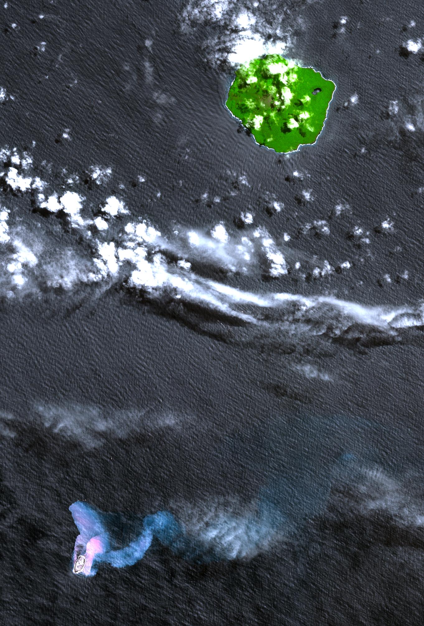
In the South Pacific, south of Late Island along the Tofua volcanic arc in Tonga, a new volcanic island Home Reef is being re-born. The island is thought to have emerged after a volcanic eruption in mid-August that has also spewed large amounts of floating pumice into Tongan waters and sweeping across to Fiji about 350 km to the west of where the new island has formed. In 2004, a similar eruption created an ephemeral island about 0.5 by 1.5 km in size; it was no longer visible in an ASTER image acquired in November 2005. The following simulated natural color image shows the vegetation-covered stratovolcanic island of Late in the upper right. Home Reef is found in the lower left. The two bluish plumes are hot seawater that is laden with volcanic ash and chemicals; the larger one can be traced for more than 14 km to the east. The image was acquired on October 10, 2006, and covers an area of 24.3 by 30.2 km.
https://photojournal.jpl.nasa.gov/jpeg/PIA01899.jpg